Existing Orienteering Maps in the Deleware Water Gap Area
The existing maps of Stuckey Pond and Spackman Creek are available using RouteGadget. Courses are from the event in 2003.
Copies of Stuckey Pond and Spcakman Creek are also available for purchase. They may be ordered during registration. The fee is $5 per map or $8 for both. They will be mailed if ordered before October 1. They may also be purchased at the event for $5 per map.
Sample Maps of the Terrain
Middle Distance:
Pieces of the existing Stuckey Pond and Spackman Creek maps similar to the terrain at Adams Creek. A portion of Adams Creek will be posted at a later date.


Middle 1 (pdf version) Middle 2 (pdf version)
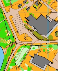
Long:
A portion of the old Stuckey Pond map that will be on the new Egypt Mills Map.

Sprint:
A portion of the new sprint map.
Relay:
Terrain similar to what will be used for the relay.

Embargoed Areas
There are several areas in the Delaware Water Gap National Recreation Area that are embargoed from now until after the event.
Schematic map of all embargoed areas. Details of each embargoed area:- Everything in the Water Gap between US 209, Little Egypt Road, Milford Road and Tumbling Waters Creek. Tumbling Waters creek is the first big creek southwest of Brisco Mountain Road. (The area between Tumbling Waters creek and Brisco Mountain Road is the portion of the existing Stuckey Pond map that was used for the Sept. 18, 2011 event and will be used for the model event at NAOC 2012.)
- Everything in the Water Gap, except the PEEC campus proper, from Brisco Mountain Road north to Hornbeck's Creek. This is the terrain on the existing Spackman Creek map. The woods and trails surrounding PEEC are embargoed; only the areas immediately adjacent to cabins, dormitories, the dining hall, the main office building, etc. are not.
- Everything in the Water Gap between Dingman's Turnpike (PA 739), Milford Road, Adams Creek and US 209.
The Event Center
The Pocono Environmental Education Center (PEEC) is the event center. Lodging is available at PEEC. The Friday dinner and Saturday banquet as well as other social activities will all be at PEEC. The Sunday races - the sprint and national team relays - will also be at PEEC.
Delaware Water Gap National Recreation Area
The Delaware Water Gap National Recreation Area encompasses nearly 70,000 acres (283 KM^2) of land along the Delaware River's New Jersey and Pennsylvania shores, from the Delaware Water Gap at I80, northward almost to the New York state line. Middle Delaware National Scenic River is a designated 64 KM section of the river entirely within the recreation area.
The recreation area runs from the northeastern outskirts of Milford, Pennsylvania (400 KM above the Delaware's mouth at the Atlantic Ocean), SW to near Delaware Water Gap, Pennsylvania. It is located in parts of Sussex and Warren counties in New Jersey, and Monroe, Northampton, and Pike counties in Pennsylvania. The Appalachian Trail runs along much of the eastern boundary.
At the south end of the park, the river cuts eastward through the Appalachian Mountains at the scenic Delaware Water Gap proper. Depending on the season, visitors can canoe, hike, camp, swim, bicycle, ski, ride horses, stop at historic Millbrook Village, and of course, orienteer. Fishing and hunting are permitted in season with state licenses. The park hosts significant Native American archaeological sites, and a number of structures remain from colonial Dutch settlements.
Source: Adapted from Wikipedia.org