- Sat - Apr 20, 2019 - Batsto
-
Navigate → 🌎
W Y O Br G R Bl

Event Director:
Course Setter: Bob Burg and see choices to Volunteer to help at this event 🙏
ED/CS Notes:
A Once-in-a-Liftime NJ Pinelands Event
Last year Batsto experienced a wildfire that engulfed about half of our map. Happily, Batsto staff decided to take full advantage of their fortune (Pineland woods depend on periodic fires to maintain robust health), and turned it into the largest controlled burn I've ever seen. Mother Nature provided the circumstance and fuel, and Batsto crew just let it run its course, serendipitously using natural firebreak features to keep it contained - the major dirt road (Goodwater Rd) that runs N/S the length of our map which was uphill and west from the fire, with the backstop of extensive marsh areas downhill to the east. Happy coincidence.
When I first saw the area in December as I started my next stage of Batsto revisions, I was astonished and absolutely thrilled. The fire transformed large swaths of unbroken slash green vegetation -- groundcover that exhausts us all when we try running cross terrain -- turning massive sections of the map into white woods full of intricate and inviting rolling hills and reentrants. A little charred around the edges, but totally runnable. It also allowed me to see the ground for the first time in DVOA captivity which enabled me to add some contour refinements and details virtually impossible to see before.
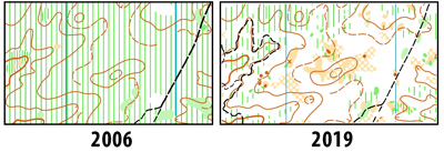
I've included two examples of one small section to whet your appetite, (PLEASE INSERT THE TWO JPGs HERE, BOB) comparing our original 2006 map with the new 2019 version. It's an area that was virtually unusable before -- even to run orienteers through -- since the groundcover was consistently waist high, growing higher and progressively denser over the years.
Undoubtedly, over the next few growing seasons, I will need to gradually add slash green back onto the map. But for this year, we have such a unique opportunity to enjoy the best of the pineland terrain without having to bail out to the nearest trail. Yellow will get a taste of it, Orange through Blue courses will get a full dose.
So please forgive my unbridled enthusiasm. The Pinelands were part of my childhood, my family's tap water directly from its legendary aquifer, drives through it on daytrips to the shore, swimming several times each summer in Pakim Pond and other cedar water lakes. I am so at home in its unique beauty. This is icing on my O-cake.
ED/CS Notes
Of course I'm hoping for a great turnout for this rare opportunity. So please consider helping out for an hour or two - with morning set-up, first shift before you run/walk a course, relief shift after you run/walk a course, or help us gather up everything at end of day. Only welcoming good spirits is necessary. Prior experience is a bonus.
Given the conditions in the woods, courses will challenge your map reading and ingenuity, but not your legs, patience, or determination. And as a bonus, only Red and Blue have any chance of topping 100m climb. Here are the course stats to date, though as I complete map revisions, I'm sure the advanced courses will change, only a little on distance and climb, perhaps a lot on route choice and control locations as I take full advantage of the white wood options. I promise, you won't just be counting fire ditches and looking for the nearest trail to bail out to.

Map Location:
Previous Results from this Map:
Dec 05, 2021
Apr 20, 2019
Apr 15, 2017
Dec 06, 2015
Feb 23, 2014
Courses Information:
Course Distance Climb Ctrls White 2.20km 32.0m 13 Yellow 3.20km 52.0m 12 Orange 4.30km 60.0m 12 Brown 3.90km 65.0m 11 Green 5.20km 75.0m 13 Red 7.20km 125.0m 16 Blue 9.40km 145.0m 22
Full Schedule (old style)
PDF Schedule
Unless otherwise noted:
- Pre-registration is recommended, discounted, and open until Thursday night, before the event.
- Day-of-registration is available, at $10 for beginners, and $20 for other courses.
All starts are from 10:00am until 1:00pm unless otherwise noted. Follow the text directions and look for Orienteering road signs as you near the park.
| Legend | |
| W | White, beginner level 3km or less |
| Y | Yellow, advanced beginner 2.5 to 4km |
| O | Orange, intermediate 3.5 to 5.5km |
| Br | Brown, Short Advanced 3 to 5km |
| G | Green, Advanced 4.5 - 7km |
| R | Red, Longer Advanced 6 - 10km |
| Bl | Blue, Long Advanced 8 - 14kms |
| Sc | Score-O |
| Sp | Sprint-O |
| Adv | Advanced |
 |
E-Punching |
 |
Confirmed Event |
| Special Event | |
| Example O-Signs: | |

| |

| |

| |

| |

| |

| |

| |

| |