45th Billygoat Run at Merli Sarnoski Park
Lackawanna County, Pennsylvania
Sunday, May 11, 2025
Additional courses offered on
Saturday, May 10, 2025

Questions? Contact
Head Goat Kyle
Results links for
Saturday | Sunday
Billygoat & Kid | Sunday Score-O/Advanced | Saturday Training | Saturday Middle
The Events – Something for Everyone
- The 45th Edition of the Billygoat Run is a long (11 – 11.5 km) orienteering course requiring advanced orienteering (or following!) skills. Finishing in under 3½ hours gets you that coveted T-shirt.
- “The Kid” is a similar but shorter version (6 – 6.5 km); no shirt.
- We will also have a 90 minute score-O geared towards beginner and intermediate orienteers, as well as two standard advanced orienteering courses (4.3km, 3.1km)
- More about the Score-O and standard courses including registration links
- On Saturday May 10th, we will offer a set of “middle distance” courses at the same site as the Billygoat. These courses will mostly use an interesting corner of the map that will not be covered in the Billygoat courses, and was only visited by the Elite courses during nationals last year.
- More information about Saturday offerings including registration links
- NEW Alex Azarov and Yury Tambasov, two of the club’s most skilled and experienced orienteers both as competitors and instructors, will lead a free training Saturday from 11-1PM.
- More information about Saturday training and registration link.
- Billygoat lore (some historical statistics and FAQs; some info is out of date)
Billygoat and Kid
Important Times
- Mass start for the Billygoat and Kid is at 11:00 AM.
- There will be a pre-race briefing at 10:50AM.
- Start is only about 100m from registration.
- All courses close at 4:00 PM; 2:30 is the cut-off to earn a Billygoat T-shirt.
Registration
- Please register at the online registration site: Event Register See who’s registered for the Billygoat/Kid. NOTE: This registration page is for the Billygoat and/or Kid, plus Saturday courses for those registering for Billygoat/Kid.
- See below for info and registration links for the Saturday courses ONLY or the Sunday Score O/Baby Goat/Infant Goat.
*** Regular registration for the Billygoat and Kid is through April 21. ***
- Register by April 21 to ensure your finishing T-shirt (if under 3 ½ hours), a nicely printed map on waterproof paper, and to avoid late registration fees. Our regular registration deadline is based on when we need to confirm our T-shirt and map printing orders.
- Late registration is from April 22-May 8. If you register late you will pay more, not be guaranteed a T-shirt, and may get a Staples-printed map.
- After May 8, please contact the event director to see if there are any maps left (or if you have to partake in the Billygoat tradition of following!).
Groups and Teams: Teams and groups are more than welcome to participate! You can also follow and collaborate with others you meet on the course (see below). However, each person should register individually.
Cost
| Billygoat | Kid | |||
| Adult | Junior (</= 20) | Adult | Junior (</= 20) | |
| Regular Registration | $38 | $20 | $20 | $15 |
| Late (after Apr 21) | $50 | $30 | $25 | $20 |
Note that the fee for the Billygoat includes your finishing (in under 3 ½ hours) T-shirt.
Event Location and Check-In
The event will be at Merli Sarnoski Park, north of Scranton PA.
- Registration/Start/Finish and Porta-Potties are all in the upper pavilion area (41.5923, -75.5401)
- Depending on how early you arrive and attendance, parking will either be adjacent to registration or may require a walk of a couple hundred meters. As you enter the park, somebody will direct you to the best available parking spot.
- On the day of the event please check in at the Upper Pavilion adjacent to the main parking lot so we can confirm your participation, check your SI number, and give you control descriptions (if you want). For Billygoat participants, you can also leave any special drinks/snacks that you want at the midway refreshment stop.
- Note that there is no potable water source at the park. We will have water available at start, on the course, and at the finish. However, we would appreciate it if you bring your own water bottle for use before and after the race.
The Courses
Approximate distances
- Billygoat: 11.4 km, 475m climb, 27 controls (one skipped)
- The Kid: 6.5 km, 270m climb, 16 controls (one skipped)
Skipped Control: One of the primary Billygoat traditions. You may skip one and only one control (this goes for “The Kid” as well). This can be any control. You may skip the first control, the last control, the control before or after the forked control or the forked control itself, or any other control. But only one. Choose wisely.
Forked Control: There is one forked control on both the Billygoat and Kid. There will be two different controls with the same number shown on the map; you choose which fork to visit (you may also choose this as your skipped control). Both controls have identical control descriptions, so you will not be able to tell from the clue sheet which control is the forked one. Pay close attention to the control sequence around the forking, as the geometry is a bit unusual!
Changing from Billygoat to Kid: The Billygoat and Kid share the same first 12 controls, and both allow for one skipped control. Therefore, any Billygoat runners who reach the refreshment stop at control 13 and decide that they want a shorter adventure can switch to the Kid. They will be provided a map showing the ~1km of remaining controls (#13-16) on the kid. Note that there is NOT an option to switch from the Kid up to the Billygoat during the event.
Billygoat Traditions
T-Shirts: Custom designed T-shirts will, as at all Billygoats, be awarded to all Billygoat registrants who finish within 3½ hours. A central tradition of the Billygoat has always been that the 3:30 limit is ruthlessly enforced. If you hear people at the finish yelling at you to run, give it all you’ve got (and then curse the course-setter for the uphill finish!).
T-shirts will be unisex and will be available in sizes XS, S, M, L, XL and 2XL. Please indicate your t-shirt size when registering for the event.
Following: Another key tradition. Following and collaboration is explicitly allowed.
Saeger Loop: This is a deliberate dogleg in an area of good visibility, which will allow you a good look at who is just ahead of you and who is chasing you.
Control Codes: Keeping with tradition, control codes correspond to the initials of the top finishers of last year’s Billygoat Run.
Club Award: The Club Award is given based solely on the judgment of the Head Goat and using criteria not announced, though in the past club spirit, enthusiasm, and perhaps most importantly bribery–which like following is explicitly allowed–have been notable features.
And the Central Billygoat Tradition: Have fun!
Safety
You must check in at the finish even if you do not complete the course. If you become very lost, bail out in the direction of the large lake at the center of the park. More details will be provided to orienteers upon check-in.
Course and Map Notes
Map Scale: 1:10,000 with 5m contours
Out-of-Bounds: There will be three out-of-bounds areas on the map marked in purple cross-hatch.
- North of start is an out-of-bounds fenced horse grazing area and stables. The fence bounding this area is barbed wire and hard to see, so will be streamered in areas close to the course.
- In the southern part of the map is private property. This area has been contracted for logging during the first half of 2025. We don’t know exactly how much will be logged by the day of the event, but there may be new clearings inside of this out-of-bounds area that are not reflected on the map.
- There is also a private property area in the northern part of the map (which is not being logged).
Please do not enter any out-of-bounds area, both to respect other landowners and preserve our ability to use the park in the future.
Map Flip: The Billygoat course will be printed 2-sided, with the start through control 14 on one side of the paper and 14 through finish on the other (control 14 is the first control after the refreshment stop). Please keep this in mind when planning skips!
Terrain: See Map Notes for more about the terrain. The majority of the Billygoat course is in open (white) woods, with only a couple of legs encountering mountain laurel.
Score-O and Standard Advanced Course
Important Times
- Check-in and starts for the score-O and standard advanced orienteering courses will be from 11:05-1:00 (you can start at any point during this 2-hour period).
- Score-O has a time limit of 90 minutes. Advanced courses have a time limit of 3 hours.
Registration
- Please register on Event Register
- See who’s registered for the Sunday non-Billygoat/Kid events
Registration deadline is May 8. We allow on-site registration for the score-O and standard advanced courses if there are extra maps available, but pre-registration is highly recommended to ensure you get a map (if you miss the registration deadline you can contact the event director to see if there are any maps left).
Groups and Teams: Teams and groups are more than welcome to participate! If you are going out as a group and staying together the entire time, one person can register the entire group (they will enter the names of others in the group during registration). For groups, the cost is the same as shown below plus $2 per additional person age 10 and older (to cover the cost of maps for everybody).
Cost
| Score-O and Advanced | Adult | Junior (<= 20) |
| Pre-Registration (by May 8) | $15 | $10 |
| On-site Registration | $20 | $20 |
Event Location and Check-In
The event will be at Merli Sarnoski Park, north of Scranton PA.
- Registration/Start/Finish and Porta-Potties are all in the upper pavilion area (41.5923, -75.5401)
- Depending on how early you arrive and attendance, parking will either be adjacent to registration or may require a walk of a couple hundred meters. As you enter the park, somebody will direct you to the best available parking spot.
- On the day of the event please check-in at the upper Pavilion (adjacent to the main parking lot).
- Note that there is no potable water source at the park. We will have water available at start, on the course, and at the finish. However, we would appreciate it if you bring your own water bottle for use before and after the race.
The Courses
Approximate distances
- Score-O: 35 controls, up to about 6.0km to reach them all, 90 minute time limit.
- Baby Goat (~Green Advanced Course): 4.4 km, 180m climb, 12 controls
- Infant Goat (~Brown Advanced Course): 3.1 km, 100m climb, 13 controls
Score-O Logistics
On the map for the score-O you will see 35 controls. You have 90 minutes to visit whichever controls you want to in any order. Each control will have a value from 10 to 50 points, with higher value controls generally being harder to find. Your score is the sum of the point values for the controls you visit. If you take longer than 90 minutes, you lose 50 points for each minute you are late (rounded up), so don’t be late!
You are welcome to look at your map before you start in order to plan your route. There are controls at a variety of difficulty levels, ranging from beginner controls directly on trails to advanced controls on small features far from trails. This will allow you to plan an adventure that fits with your experience and interests. We will have volunteers at the start area who will be happy to help you plan a route at the difficulty level you desire.
Safety
You must check in at the finish even if you do not complete the course. If you become very lost, bail out in the direction of the large lake at the center of the park. More details will be provided to orienteers upon check-in.
Course and Map Notes
Map Scale:
- Baby Goat (Green): 1:10,000 with 5m contours
- Infant Goat (Brown) and Score-O: 1:7,500 with 5m contours
Out-of-Bounds: There will be three out-of-bounds areas on the map marked in purple cross-hatch.
- North of start is an out-of-bounds fenced horse grazing area and stables. The fence bounding this area is barbed wire and hard to see, so will be streamered in areas close to the course.
- There is an unfenced private property area in the northern part of the map.
- Green Course only: In the southern part of the map is another area of private property. This area has been contracted for logging during the first half of 2025. We don’t know exactly how much will be logged by the day of the event, but there may be new clearings inside of this out-of-bounds area that are not reflected on the map.
Please do not enter any out-of-bounds area, both to respect other landowners and preserve our ability to use the park in the future.
Terrain: See Map Notes for more about the terrain. The majority of the courses are in open (white) woods, with almost no mountain laurel except for a couple of legs on the Green course.
Saturday Middle Distance Courses
On Saturday we will have intermediate and advanced “middle distance” courses at the same site as the Billygoat. These courses will mostly use an interesting corner of the map that will not be covered in the Billygoat courses, and was only visited by the Elite courses during US Nationals last year. For beginners, we will also offer a newly installed permanent course.
Important Times
- Check-in opens at 1:30PM.
- Starts any time from 2PM to 4PM.
- Courses have a time limit of 2 hours. All courses close at 6PM.
Registration
- Use this link to register ONLY for the Saturday middle courses
- See who’s registered for the Saturday courses
Registration deadline is Thursday, May 8. We allow on-site registration if there are extra maps available, but pre-registration is highly recommended to ensure you get a map (if you miss the registration deadline you can contact the event director to see if there are any maps left).
Groups and Teams: Teams and groups are more than welcome to participate! If you are going out as a group and staying together the entire time, one person can register the entire group (they will enter the names of others in the group during registration). For groups the cost is the same as shown below plus $2 per additional person age 10 or older (to cover the cost of maps for everybody).
Cost
| Saturday Middle | Intermediate and Advanced Courses | Beginner Permanent Course Map |
| Pre-Registration (by May 8) | $10 | $2 |
| On-site Registration | $20 | $2 |
Event Location and Check-In
The event will be at Merli Sarnoski Park, north of Scranton PA.
- Registration/Start/Finish and Porta-Potties are all in the upper pavilion area (41.5923, -75.5401)
- Depending on how early you arrive and attendance, parking will either be adjacent to registration or may require a walk of a couple hundred meters. As you enter the park, somebody will direct you to the best available parking spot.
- On the day of the event please check-in at the upper Pavilion (adjacent to the main parking lot).
- Note that there is no potable water source at the park. We will have water available at start, on the course, and at the finish. However, we would appreciate it if you bring your own water bottle for use before and after the race.
The Courses
Approximate distances
- Beginner (Permanent Course): ~2.5km, ~60m climb
- Orange (Intermediate): 2.3km, 65m climb, 11 controls
- Brown (Short Advanced): 2.3km, 70m climb, 8 controls
- Green (Medium Advanced): 2.9km, 115m climb, 10 controls
- Red (Long Advanced): 4.2km, 150m climb, 15 controls
Safety
You must check in at the finish even if you do not complete the course. If you become very lost, bail out in the direction of the large lake at the center of the park. More details will be provided to orienteers upon check-in.
Course and Map Notes
Map Scale: 1:7,500 with 5m contours
Out-of-Bounds: There will be two out-of-bounds areas on the map, marked in purple cross-hatch.
- Private property on the southern edge of the map is marked as out-of-bounds. The eastern section of the private property has been contracted for logging during the first half of 2025. We don’t know exactly how much will be logged by the day of the event, but there may be new clearings inside of the eastern out-of-bounds area that are not reflected on the map.
- North of start is an out-of-bounds fenced horse grazing area and stables.
Please do not enter any out-of-bounds area, both to respect other landowners and preserve our ability to use the park in the future.
Terrain: See below for detailed notes about the map. The Saturday courses will encounter a bit more light and medium green (vegetation) than the Billygoat. These areas will reduce visibility and increase the navigational challenge, but don’t involve any thorns, so won’t slow travel too much. The north-facing slope in this area also has some areas of deadfall.
Saturday Training
We invite orienteers of all levels and experience to participate in a free technical orienteering training on Saturday, May 10th at Merli-Sarnoski Park!
Training will happen just before orienteering courses, so feel free to join us and explore two crucial lessons:
- Direction and how to use the compass – 11AM – 12PM
- Contours and shapes – 12 – 1PM
Training will be organized by Alex Azarov and Yury Tambasov and will be mostly theoretical with some short very low intensity exercises (walking). Training is free; no participation fee.
Pre-registration is required. Training will be at the same pavilion as the registration for Saturday’s courses.
If you have any questions feel free to ask Alex and/or Yuri
Map Notes
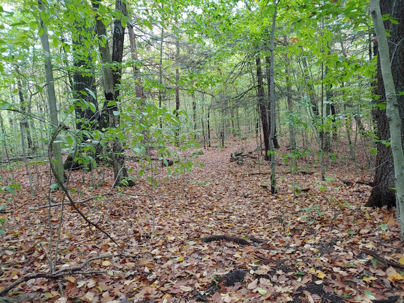
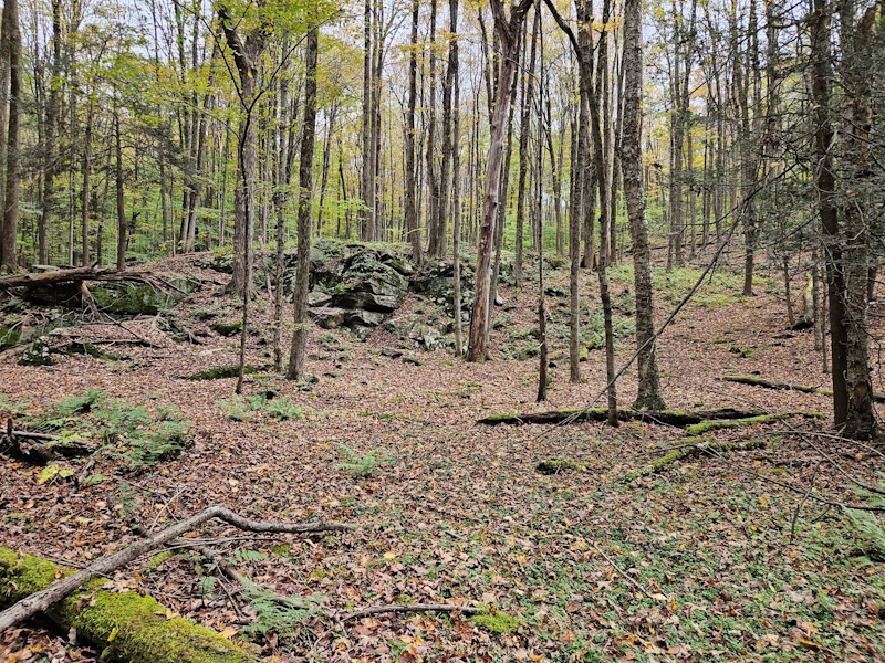
Terrain: The terrain varies considerably across different parts of the course. There is a large lake roughly in the center of the map surrounded by hillsides, with a few small streams separating the hillsides. Some sections include intricate rock and cliff detail, other sections have open woods and little ground cover. Light and medium green on the map are usually areas of younger trees that somewhat impact speed and visibility. Dark green and green slash areas are generally different heights of mountain laurel – the laurel on this map will slow you down but is passable. Thorns are pretty much non-existent. The trail network is moderate, with a few large, relatively straight trails and a number of smaller, twisting mountain-bike trails which can sometimes be tricky to see (especially in rocky areas). Some areas contain artifacts from past coal mining operations.
Permanent Course: We are currently installing a permanent orienteering course in the park. You may see stakes with pinks streamers that say “DVOA PC” on them out in the woods, including a couple near control locations. If you see a streamer but not your control, it is not because a Billygoat walked off with the flag; the streamer is for a different purpose and you still have to find your flag.
Map History: The map of Merli-Sarnoski was produced for the 2024 US National Championships with very minor revisions since. So you can expect the vegetation mapping to be accurate for navigation.
You can see the map used for US Nationals on Livelox here: https://www.livelox.com/Events/Show/139548/Merli-Sarnoski-Long
Sample terrain photos, including some of the mountain bike trails in the park, cliffs, and boulders!