Trail-O
The content on this page was provided by Karl Ahlswede, Richard H. Ebright, and Nancy Sharp. The examples below are from a Trail-O event (The 2012 Ridley Riddle) held in conjunction with a DVOA local meet at Ridley Creek State Park in December of 2012.
Trail orienteering (also known as Precision Orienteering) is a navigational challenge, suitable for anybody willing to test themselves in precision map reading. While in classic orienteering the goal is to traverse the terrain as quickly as possible between pre-specified locations, in trail orienteering how quickly you complete the course is not as important as how well you can interpret the map. Trail-O levels the playing field for people with different physical abilities by testing the competitors solely in their ability to interpret the map. To allow for all competitors (able-bodied persons and persons with physical disabilities alike) to compete on equal terms, trail orienteering is held on wheel-chair compatible roads or trails. All other areas are out of bounds.
Trail-O events use the same orienteering maps as regular events, but typically the map is at a larger scale (1:5000). Another difference is that, unlike in classical orienteering where only one control marker is hung in the control circle, in Trail-O up to five control markers may be hung at each site, and at most one will correspond exactly to the control description and the control circle position.
Trail-O competitors have to visit the control points in a set sequence. They are asked to interpret the map and to choose which, if any, of the control markers represents the one that is in the center of the control circle and is correctly described in the control descriptions. This choice is made at a decision-making point, which is marked in the terrain but is not marked on the map. This is important, because control markers are designated as 'A', 'B ... 'E,' (from left to right) as they appear when viewed from this decision-making point.
Once you make a decision that one of the visible markers is correct, you punch the letter identifying that marker on your card. If you decide that none of the visible markers are correct, you can punch the letter 'Z' (none of the above) on your card. Any line on the control card showing more than one mark, or no mark, is deemed incorrect. No change in punching is permitted, so be sure you're on the right line and in the answer box you intended before you mark your card. Each correct answer counts as one point.
In addition to the standard Trail-O controls, one or more 'timed control' may also be included in the course. At a timed control, both accuracy and time are important. The competitor is positioned so that all relevant markers are visible, and a correctly oriented map segment is handed to the competitor as a stopwatch is started. The map segment has one circle, and one control description. The time stops when the competitor selects an answer or after 60 seconds, whichever comes first. A correct answer counts as one point, and the competitor's time is recorded. An incorrect answer counts as zero points, and the competitors' time plus 60 seconds of penalty time is recorded.
The competitor who completes the course within the overall time limit established by the course setter (e.g. two hours) and who has the highest overall number of correct answers is the winner. In the event of a tie, the tie is broken based on the times at timed controls.
Click here for a sample from one of our local trail O events.
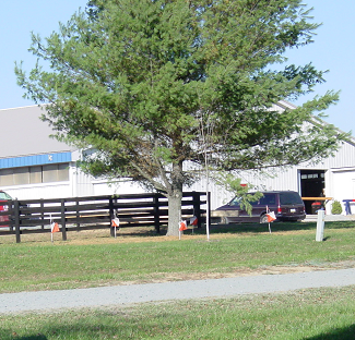
Example #1
 |
 |
| In this example the problem is to identify the correct side of the tree. The Clue sheet tells us it's on the North side, so it's simply a matter of identifing which control is to the North. The viewing direction is towards the Northeast, making "B" the correct answer. | |
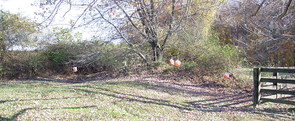
Example #2
 |
|
 |
|
| In this example the problem is to identify the correct side of the earthen embankment of the earth wall. The viewing angle is towards the Southeast. The correct answer is "B" | |